Finally a day of sunshine, others may have been luckier than me but this would be my first really good flying weather day of 2013.
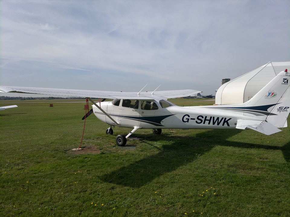
G-SHWK
It’s been just over a year since I last flew with my instructor for today, but that being said on the two occasions we have flown together, for no directly tangible reason I’ve come away feeling like I’ve learnt loads. Maybe it’s an experience thing, maybe it’s a training style thing, but some people you just seem to learn from really easily. Still, a bit bizarre though that the last time we were in a plane, I was being taught slow flight and had never flown a circuit – today we’d be doing an 88 mile flight and if he touched the controls, the lesson would be going badly wrong. Strange.
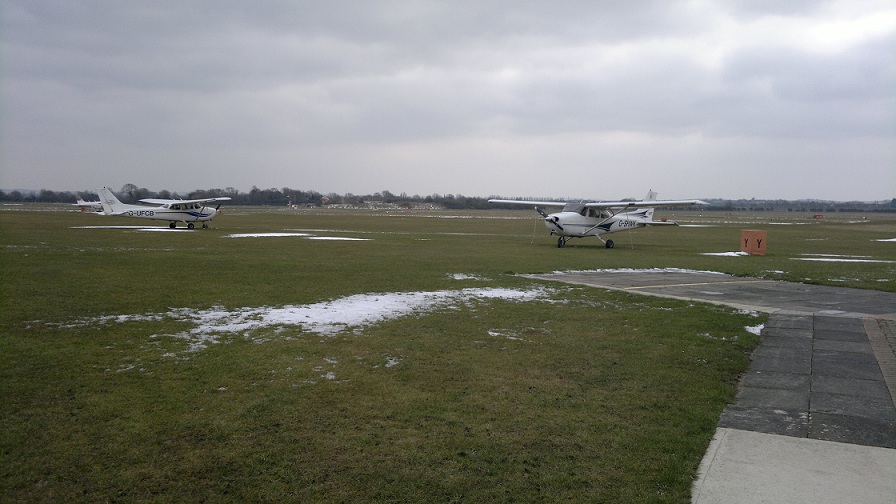
Another instructor had taken Romeo Charlie, so I got my pick of the planes, we’ll take G-SHWK.
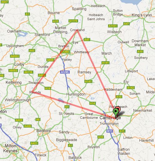
The Route
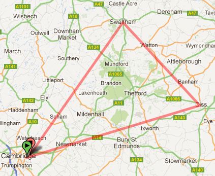
General Route: Diss, Swaffham
I get the impression that, as you might expect, each Nav. lesson adds a different element into the mix and builds on the previous ones. From this route you sort of get the impression it’s building on the RT side of things and also adds the addition of nearby danger zones and the potential to encounter fast moving stuff.
Flying up to Diss takes you through the Mildenhall/Lakenheath Combined Military Aerodrome Traffic Zone (CMATZ). Lakenheath is home to a lot of USAF: F-15’s, while Mildenhall is home to a lot of big military tanker aircraft. The runways at both are immense, Lakenheath’s being 9,000ft and to give you some perspective, Cambridge is 1 mile of runway – Lakenheath is 1/3 longer! Just to add to the fun, there’s a danger zone over Thetford where fast jets go to play “how low can you go….” types of games.
The top of the triangle touches into RAF Marham MATZ, it was expected they wouldn’t be there today but if they were it would be one more RAF controller to talk to.
Give a student an inch and they’ll take a mile….
With Runway 05 in use today & power checks done, we were cleared to enter the runway from Delta and take off as ready. From holding point Delta you already have well over the take off run required of a C172, you could probably take-off, abort and take off again no worries at all…….so why I decided to turn right and grab a little extra runway I’m not sure (technically I wasn’t cleared to backtrack either). Anyway, that minor mental slip aside, a fairly nice take-off and climb out.
Turning right to head south to catch the runway that leads to Six Mile Bottom, I overshot it a little in my search (Railways are smaller then you’d think), but we were soon on our way to the first check point.
Not an immense amount of time from Six Mile Bottom before you’re on the edge of Lakenheath CMATZ, so my flight plan notes show and arrow at Six Mile Bottom to Lakenheath’s approach frequency (a visual reminder to swap frequencies and get MATZ penetration clearance at this checkpoint, a very useful tip on flight plans).
I was expecting a military sounding controller, but all the same this controller sounded much more serious and to the point then the RAF controller I’d spoken to fly through Wattisham MATZ. Straight to the point we were given a squawk code and cleared to penetrate Lakenheath CMATZ, in addition although we asked & got a basic service, we also got a Radar service (would come in handy shortly).
Traffic, 8 miles, 12 O’Clock
While in the middle of convincing myself (and talking my thought process outloud “just for info” to my instructor) that Bury St. Edmunds was in fact where I expected it to be and we were just past a round about as shown on the map, so reassuringly were dead on course, almost to the second. Lakenheaths controller called us.
G-WK, Traffic, 8 miles, 12 O’Clock……
I called them back to say we were looking but did not have visual contact, now things started to get a bit more interesting:
G-WK, traffic, 7 miles, 12 O’clock
Still looking
G-WK, traffic, 6 miles, 12 O’clock…….Recommend Climb.
When a controller with a radar tells you to climb, I’m of the view your best move is to do as they say immediately! Remember I said they operate F-15’s at Lakenheath, who knows if we’d ever see this traffic.
Just as I pressed the Mic button to reply “G-WK climbing….” I got visual with the traffic, it was 12 O’clock, low, maybe 700ft below us and now maybe only 3 miles out. “…..and visual with traffic.” Quite pleased to find it wasn’t a fast jet.
From here on in it was a pretty smooth flight to Diss, my instructor pointing out a smoking chimney to our right along the way and how it could be used to consider wind direction (and whether it was as per forecast etc.).
Almost to the second Diss was below us, you’ve gotta love it when dead reckoning works 🙂 Diss is fairly easy to identify, it has a railway line running north to south and an industrial section to the east, which if you’ve done your Google Earth homework is very handy.
North to Swaffham
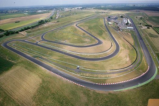
Snetterton Race Track
Gotta admit I was looking forward to this leg, the planned route would take us just right of Snetterton race track and it would be a fun landmark to sightsee from the air.
Snetterton didn’t let me down, being a weekend they had a race going on, from 2,500ft it was like watching toy cars speeding along but you could clearly make out the track and the racing – would have been really fun to orbit here for a bit and enjoy the race, but we had to crack on.
Just past Snetterton my expectant wind farm let me down, stupidly I’d decided a mast would be a wind farm and was trying to mentally force things into position when I couldn’t find the wind farm. However, the town of Watton has a distinct shape, so after a bit of hmming and arrghing (and accepting the elapsed time couldn’t be far wrong), I had a rethink on my position and all was well with the world again.
Swaffham however, does have a wind farm just north east, so again easy to identify the correct town with key landmarks like that.
For not the first time this flight I was reminded to raise the wing before turning on to the new heading. Hmmm, seems to be the latest creeping in error, I used to be meticulous about this in circuit flying, I guess instructors have let me get away with it and it’s warn out of my memory.
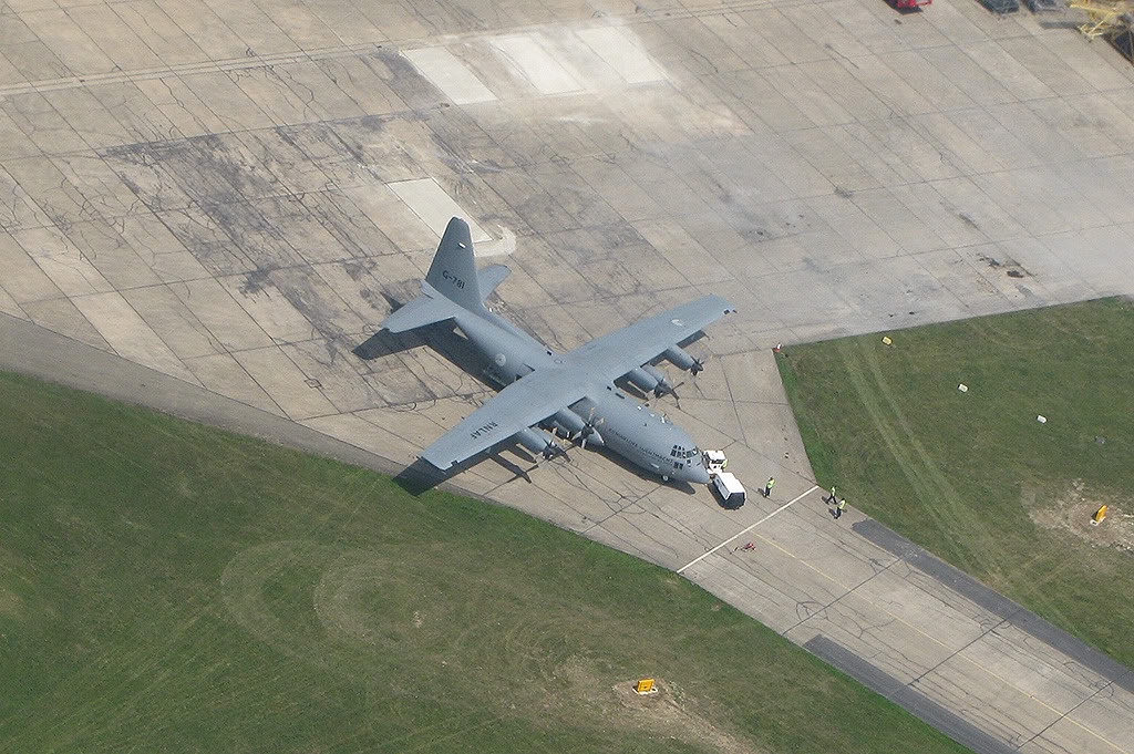
Visual with Lakenheath
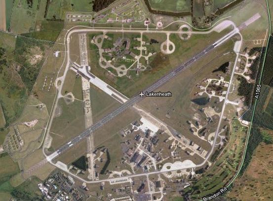
RAF Lakenheath
You can look at it on Google Earth, but you don’t fully appreciate it, as noted at the beginning, Lakenheath’s runway is immense! From 2,500ft up, approx. 4.5 miles north, it was blatantly impossible to miss the almighty runway out of the left window, surrounded by airfield buildings and big open space. A very impressive sight, but I don’t think they’d take too kindly to us landing there (or getting close, so we’d keep well clear).
All credit to them though, Lakenheath ATC continued to be good to us.
Time for a bit of a Diversion
Just passing Soham my instructor asked me to plan a route to fly to Wyton.
Not being a million miles off course this was a reasonably straight forward new heading to judge, we then used other land marks including the now unused RAF runway at Waterbeach to verify our position and that our heading was going to work out. A few top tips along the way, but this all went ok.
Finding the way home
This last minute diversion, right on the boundary of where we’d normally be asking for rejoin sent the workload skywards. Now there was a stack of stuff to do and I began to really think “where the heck is the runway going to be…….” Weird, because I could see the A10 so I knew where I was, it’s not like the runway would have moved, but suddenly the city of Cambridge seemed less familiar in shape.
A half decent radio call to rejoin, resulted in getting a downwind join. The picture all started to come together, but I’m not sure I could recall how it was I got there. This tells me the work load was running high.
Up until very recently I’ve landed with nothing on my lap, now I’m landing with a ton of things on my lap (knee board, map, flight plan….) and it’s just a bit weird – half expect it all to hit the deck any second. Still the landing was ok, it wasn’t my greatest, smooth but I touched down on the back left wheel first and a bit flat. My instructor took the opportunity to raise the nose after landing to remind me of the perspective I should have for an ideal landing – all good, but unless it’s flapless, rarely do I let myself do it like this.
All in all a very enjoyable flight, I rarely fly with this instructor but wish we could have more lessons as I just seem to get a lot out of them.
Next up, Nav #4……..down to Luton.