Just for a laugh we’ll do the flight plan. Watching trees outside getting practically blown over and looking at a Met Office Form 214 Spot wind chart suggesting there was a 35 Knot @ 2,000ft. Forget it, but the speeds would be ridiculous so I’d do the plan anyway….
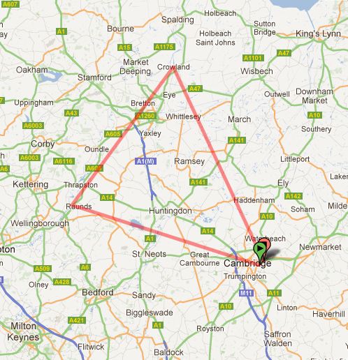
General Flight Path
This trip would take me further West and North then I’ve ever flown before:
- Raunds
- Crowland (Just North of Peterborough)
- Back to Cambridge
It’s sort of strange that for this many hours you stay so close to your home airfield, but there’s no reason really to go further afield.
Now the trips are starting to get a bit more interesting in terms of mileage, roughly speaking this is a 97 statute mile round trip.
The last Nav. couldn’t go too far wrong, point a plane east from here and short of an engine failure, you will find the coast. Today we’d have to find two small villages and if I found the coast while flying west, something would be very wrong.
The Wind and Snow
Strangely on arrival the wind had calmed a little, but was still gusting to 21 Knots, however as luck would have it today, gusting straight down the runway between 10 degrees and 50 degrees. So what would otherwise be a show stopper, was actually not a problem at all. As for the 35 knot winds at 2,000ft also fine, there was nothing to suggest we’d have any problems trying to take off or land. So bizarrely, we were on.
A few minor suggestions on my flight plan, but no changes required and it all looked good so we’d go with it as is.
The leg up to Peterborough crosses RAF Wittering MATZ (Military Aerodrome Traffic Zone), so we had a quick chat about calling them up and it was noted that they often aren’t there! If they didn’t answer our calls we’d call up London Information and get a Basic Service off them (Hmmm, never spoken to London Information, something new to try), I don’t really know why this seemed more daunting then calling RAF Wittering, maybe because of the potential for more people to be listening.
NOTAM’s and other documents checked, it was off to check the plane – largely through my preference we took G-SHWK, it is my favorite and I rarely miss a chance to fly it.
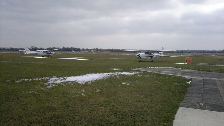
G-SHWK in the Snow
Today however, it was ridiculously cold, the wind was just making it all the worse. Just stopping the planes’ door from blowing off in the wind was a challenge and my hands were going red with the windchill. A broom was required to get some snow off the stabilizer, but other than being cold, Whiskey Kilo was looking in pretty good shape.
I’d made a mental note I wanted to check the sense of the altimeter in G-SHWK, and sure enough it was the “correct” sense (e.g. 1 knotch ABOVE say 1010hPa is 1011hPa), as noted in an error repeatedly made in my last lesson, G-HERC’s altimeter has what I’d describe as an inverted sense (e.g. 1 knotch ABOVE 1010hPa is actually 1009hPa). Given that I fly G-SHWK alot, that would explain that error.
Go, Go, Go….
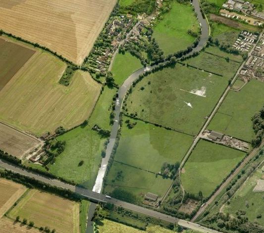
River Cam
Having spent a fair old while sorting the plane and talking through the route and weather, my instructor blitzed the start-up checks and engine start-up. Taxi clearance was all good except I misheard holding point Charlie for Delta (hear what you expect to hear I guess), easy enough to sort out and just to be random we took a whole new route to get there (40+ trips and I’m still being given new ways to taxi around the airfield!).
After a seeming age of waiting for the engine temperatures to get into the green, we were soon out on runway 05 and being cleared for take-off.
The left turn out from 05 I always associate with a chance to look down and see the river cam, it’s rare to fly out this way and it’s a nice view – especially if people are out rowing.
All that was left to do from here was point the plane in a westardly direction and find Point Alpha, it seems weird to suggest it now, but it’s pretty straightforward to find this land mark.
Set the Clock – 35 Knot wind you say!
With a heading of 296 degrees set, the distance of 12 miles to my first way point of Buckden would take just 5 minutes 30 seconds! My flight notes tell me that we got there 2 minutes late, I guess the wind wasn’t quite all what had been forecast (Not quite realising the full significance of this late arrival would come and get me later).
I was about to fly further West then I’ve ever flown (myself) before
As we flew over and past Grafham water, another minor but important tick box of firsts was crossed off. This was as far west as I’ve ever flown a C172 before, so far Grafham water has been a virtual barrier beyond which I’d never been allowed to venture – we would press on from here though, next way point was
They don’t seem to appear on Google Earth photography, but the fairly ‘recent’ sprouting of Wind farms is in my opinion an aviation blessing, they sure make navigation easier. Raunds now has the “luxary” of a wind farm just “behind” it (well closer to Kettering), meaning that the ‘town’ with a wind farm directly west of it and a bigger town to it’s south (Rushden) and a fairly major road adjacent to its west side is very likely Raunds.
So far, so good.
London Information Calling
With a new heading of 051 set and an ETA to the A1/Services, just south of Peterborough of 11 minutes, all that was really left to do was to request a frequency change from Cambridge Approach and try our luck with RAF Wittering (129.975).
Of course that frequency meant I had to learn the radio had additional switches I’d never played with before, more toys 🙂
As much as I wanted Wittering to reply, sadly after two attempts I had to accept nobody was home. Time for plan B: London Information.
Another first, I’ve never spoken to London Information before, I could live without having to but life would be boring without new experiences. To no surprise, they were there and asked us to set a squawk code I’ve since forgotten (possibly 6521), the radio call all went nice and smooth and London Information seemed happy enough to entertain our flight and Basic Service request.
The Leg Home : Navigation at lower altitude
Peterborough seemed easy enough to find and from there Crowland just north east of it with a river on its west side was reasonably easy to identify. However, up until this point I’d elected to fly at 2,500ft, I knew from my previous lesson that navigation was easier at this altitude (at this altitude the forward/down visibility is ~5 miles). Now my instructor ‘suggested’ we try descending to something lower, I compromised with him and settled on aiming to fly at 1,600ft (this would kill the forward visibility, down to ~3.4 miles).
Interesting fact: If the flight visibility was <= 5Km you’d be at the limits or out of VFR flight and the book of words on the topic will tell you that navigation is going to be very difficult unless you really know the area. It just so happens that 3.4 miles = 5.5Km, which gives you some idea of what Navigation at this altitude is like.
This was made worse because the weather was blowing the plane all over the place, it was a fight to stay in trim and when it was, it never lastest. At times the altitude was down to 1,300ft (not ideal, my flight plan showed a Minimum Safety Altitude of 1,500ft).
Remember how I arrived late at Buckden, suggesting the wind was not as forcast, well that wind was supposed to have been a massive 35 knots from 080 degrees (essentially a full on cross-wind for this leg), so the compensated flight plan had adjusted a True Track of 154 degrees, to a True Heading of 135 – if the wind wasn’t as forecast I was going to be flying 20 degrees off course!
The magnitude of this difference is hard to express in words, but the accuracy of the forcast had the potential to essentially decide which side of Ely City I flew!!
So it will hopefully come as no surprise then that on this leg of the trip I found myself “sort of” knowing where I was. Forget finding Fen End Farm as planned and in the effort to work out where I was I left it quite late to contact Cambridge Approach again, requiring an orbit to buy some time to get cleared for the rejoin.
Still it was all good and the call to Approach and Tower went better then it has typically done recently.
Landing……..could you move the C-130 please?
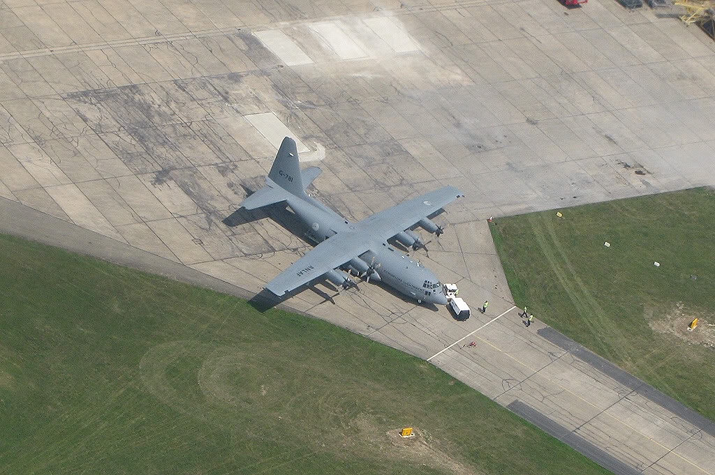
C-130 Holding
The circuit I was generally happy with, but ATC called and told us to report final not sooner than 2 miles out which meant extending downwind quite a way, it’s been an age since I’ve approached from this distance.
The reason was that a C-130 was doing an APU check and was currently sat on runway 05 exactly where I wanted to land. A go around can be easily converted into financial terms of about £30, maybe when I landed someone would tell me where to send the bill….
Thankfully however, that was not required, as the last stage of flaps were lowered and we descended through 600ft, the beast of a plane started to lumber off the runway and we kept coming down and down until with about 400ft to go we got the clearance to land. I rattled off a quick response but was mentally very busy trying to stop the wind and keeping the plane on course, there were points in this descent where I knew I absolutely had it, you know when you’ve got it just right because everything slows down and the descent becomes effortlessly calm. Then the wind would gust and it was back into getting it all back to being calm again.
Touch down was a bit further in then I’d originally hoped, but it just wouldn’t quite go down that last 50ft, but we landed with a mass of runway to spare and I’d take the landing any day of the week although not my smoothest ever, given the wind not too bad.
All in pretty happy, the last leg could have been better but I’m starting to get quite comfortable with flying completely out of sight of the airport and having a map on my lap and attempting to scribble ETA’s etc.
Next trip is out towards Thetford, so fingers crossed for some good weather.