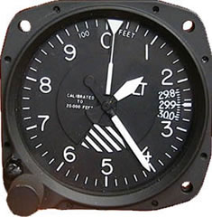
 Altimeters give a measurement with respect to air pressure, they are therefore essentially a sensitive barometer. It’s the age old way of measuring an aircraft’s altitude and as such the equipment is arguably more robust than ‘modern’ advances such as GPS. Additionally not all light aircraft have GPS fitted, so it’s important to know how it works and what it is actually telling you (not necessarily your altitude!).
Altimeters can only tell you: Vertical distance above the datum selected.
So if you leave the altimeter alone for long enough and just keep flying at a ‘constant’ indicated altitude, as pressure changes – so will your real world / true altitude. This is because if the pressure goes down and you keep flying a ‘constant’ altitude on the altimeter, you’ll actually be descending. Thus the saying “High to Low, down you go….”. The reverse is equally true, giving the saying “Low to High, up you fly.”
It’s what can cause pilots crash into hill sides.
To avoid this problem, the altimeter needs to be regularly calibrated against a known pressure (datum). There are three types available:
- QNH : Altimeter reads aircraft Altitude above mean sea level.
- QFE : Altimeter reads aircraft Height above a set datum (e.g. height above the airfield).
- Flight Level (FL): Altimeter reads flight level above 1013mb/hPa of mercury.
QFE is by its nature localised, but good for flying in airfield circuits (you’ll land with the altimeter reading 0ft which is reassuring). For cross-country QNH is typically more commonly used.
QNH gives altitude relative to mean sea level, good because everything else that is high is measured with respect to sea level. QNH once set is only valid for the Altimeter Setting Region (ASR) you’re in and then only valid for one hour.
Flight Level (FL), above the Transition Level you can fly at ‘Flight Levels’, you’ll see them abbreviated to FL35 for example (FL35 = approx. 3500ft). Typically the transition level is 3000ft but…. Not all flight levels are available all of the time, for reasons that will remain for another post. Above the Transition Level, the altimeter can be set to the International Standard Setting of 1013mb/hPa. The theory behind flight levels is fairly straight forward, at this setting everyone is flying at a relative level, they’re all going up and down with respect to each other in the same area of pressure. So even though their indicated altitudes may not perfectly match their true altitude, a pilot flying at FL35 and a pilot flying at FL40 in the same area are in no risk of crashing into each other (even if for this example they’re a bit close).
Don’t forget Temperature….
It was all going smoothly, yet it doesn’t stop there, the thing with pressure is it changes with temperature. Consequently if you’re flying on a very hot day then the same pressure will now be at a higher altitude – the catch being altimeters are calibrated against the International Standard Atmosphere (Temperature at Sea Level is +15C with a lapse rate of 2C per 1000ft). If the air your flying in is hotter than this, then the altimeter will be wrong and the aircraft will be higher than indicated. Equally on a cold day, you will be lower than indicated.
All that being said, the error temperature plays on altimeters is small (but many small errors add up, so it’s worth remembering)
……..now you know why the US Military thought GPS would be a pretty neat idea!
